How to Navigate Without GPS: A Primer on Map and Compass Skills
In an age of instant directions and satellite tracking, the art of traditional navigation can seem like a relic of the past. But technology, as reliable as it often is, has its limits. Batteries die, signals drop, and screens break.
Whether you're deep in the wilderness or simply exploring a new city, relying solely on GPS can leave you vulnerable. The confidence that comes from possessing traditional basic navigation skills is irreplaceable. It's the freedom of knowing you can find your way, no matter what. This guide is your primer on the foundational skills of survival navigation: using a map and compass.
Understanding Your Compass
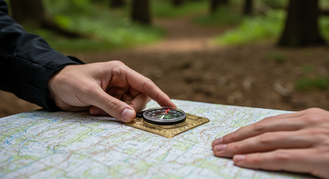
Your compass is the most crucial piece of your non-digital navigation toolkit. While there are many types, a baseplate compass is the most versatile for map work.
-
Anatomy of a Baseplate Compass: Familiarize yourself with its key parts: the baseplate (the clear plastic bottom), the direction-of-travel arrow, the rotating bezel (or azimuth ring) marked with 360 degrees, the magnetic needle (the red end always points to magnetic north), and the orienting arrow and lines inside the housing.
-
Finding North and Taking a Bearing: To find north, simply hold the compass flat and let the magnetic needle settle. The red end points to magnetic north. To take a bearing on a distant object (like a mountain peak), point the direction-of-travel arrow at the object. Then, rotate the bezel until the orienting arrow lines up with the red magnetic needle. The number on the bezel that aligns with the direction-of-travel arrow is your bearing.
Reading a Topographic Map
A topographic map is a powerful tool that shows the three-dimensional shape of the land on a two-dimensional surface. Mastering map reading basics is essential.
-
Understanding Contour Lines, Scale, and Legend:
-
Contour Lines: These brown lines connect points of equal elevation. The closer the lines are together, the steeper the terrain.
-
Scale: The map's scale (e.g., 1:24,000) tells you the relationship between distance on the map and distance on the ground.
-
Legend: The legend is your key to the map's symbols, explaining what features like streams, trails, and buildings look like.
-
-
Identifying Key Terrain Features: By reading the contour lines, you can visualize the landscape. Circular contour lines indicate a hill or mountain. V-shaped lines pointing uphill show a valley or drainage, while V's pointing downhill indicate a ridge.

Putting It Together: Basic Techniques
This is where the magic happens, combining your two tools to navigate effectively.
-
Orienting Your Map: Place your compass on the map and rotate the map until the north-south lines on the map align with the magnetic needle of your compass (which is pointing north). Now your map is oriented to the actual terrain around you.
-
Taking a Bearing from the Map: To walk from point A to point B on your map, place your compass on the map with the edge of the baseplate connecting the two points. The direction-of-travel arrow should point towards B. Rotate the bezel until the orienting lines on the compass are parallel with the north-south lines on the map. Now, take the compass off the map, hold it in front of you, and turn your body until the red magnetic needle is inside the orienting arrow. The direction-of-travel arrow now points exactly where you need to go.
-
Triangulation: Finding Your Position: If you're lost, you can find your position by taking bearings on two or three known landmarks that you can also see on your map. After taking a bearing to the first landmark, orient your map. Place the compass on the map so one corner is on the landmark, and pivot the whole compass until the orienting arrow and magnetic needle align. Draw a line along the baseplate's edge. Repeat this for a second landmark. Where the two lines intersect is your approximate location.

Practical Exercises for Beginners
Like any skill, navigation requires practice. You don't want your first time trying these techniques to be in an emergency.
-
Practice in a Local Park: Take your map and compass to a large local park or a familiar hiking area. Practice orienting your map. Pick a visible object, take a bearing to it, and walk there. Try to find your position using triangulation. Building muscle memory in a low-stakes environment is the best way to prepare for a real-world scenario.